י״ח כסלו ה׳תשפ״ה | December 19, 2024
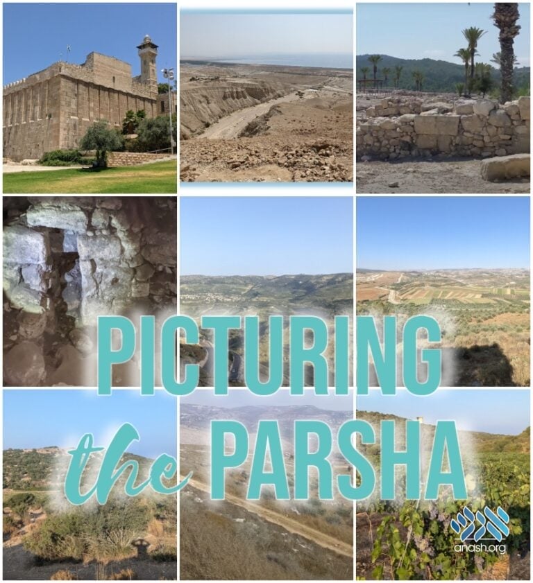
Pictorial Tour of Historical Sites in Parshas Vayeishev
Anash.org Feature: Tour the ancient sites mentioned in Parshas Vayeishev with “Picturing the Parsha” featuring unique and exclusive photos with detailed descriptions by Tanach explorer and photographer Sholom Raskin.

Anash.org Feature: Tour the ancient sites mentioned in Parshas Vayeishev with “Picturing the Parsha” featuring unique and exclusive photos with detailed descriptions by Tanach explorer and photographer Sholom Raskin.
By Anash.org reporter
In each Parsha of Sefer Bereishis, we encounter new places where our Avos traveled and settled. Wouldn’t it be incredible to see what those sites look like today?
Tanach explorer and photographer Sholom Raskin has a curiosity and fascination with real-life locations of the stories from Tanach. During his time in Eretz Yisroel, he intensely explored hundreds of historical and archeological sites and documented it all.
In this weekly column on Anash.org throughout the weeks of Sefer Bereishis, Sholom presents photos of ancient sites mentioned in the parsha. Under each picture, there will be a caption with the Perek and Posuk that is being referenced and a short explanation of what the picture is about.
A printable PDF allows for easy printing of the photos and descriptions for reading on Shabbos and showing it at the Shabbos table. Click here to download the PDF.
– For the next two weeks, during Parshas Miketz and Vayigash, the Parsha takes place in Egypt, and we don’t have pictures from there.
*
List of places in Parshas Vayeishev:
37:12 – While driving to the viewpoint that overlooks Shechem (About 30 miles north of Yerushalayim), we passed by some pasturelands next to the city of Shechem.
37:14 – Meoras Hamachpela in Chevron (about 17 miles southwest of Yerushalayim). The Rashi on this possuk, says that Yosef went to Shechem to fulfill what was told to Avraham Avinu at the Bris-Bein-HaBesarim.
37:17 – Tel Megiddo (about 20 miles southeast of Haifa), is where the Egyptians fired an arrow that hit King Yoshiyahu, who was trying to stop them from passing by. About 11 miles southeast of Tel Megiddo, past those mountains in the background, is Dosan (that area is very dangerous to visit).
37:25 – I got a car ride from Tel Saki down to Tiveria. We drove by the south of the Golan Heights (about 9 miles southeast of Tiveria). The mountains in front of us, which are located in Jordan, is the Gilead Area.
38:1 (Picture 1) – The view from Adullam overlooking the Chevron mountains (Chevron is about 10 miles southeast of Adullam).
38:1 (Picture 2) – One of the most famous descendants of Yehudah was David HaMelech, who hid inside a cave by Adullam to escape Shaul HaMelech. This is a picture from inside one of the caves in Adullam.
38:5 (Picture 1) – Today, there are many vineyards around the area of Keziv (about 5 miles south of Beit Shemesh).
38:5 (Picture 2) – Today, there are many vineyards around the area of Keziv (about 5 miles south of Beit Shemesh).
, we passed by some pasturelands next to the city of Shechem.")
37:12 – While driving to the viewpoint that overlooks Shechem (About 30 miles north of Yerushalayim), we passed by some pasturelands next to the city of Shechem.
.
The Rashi on this possuk, says that Yosef went to Shechem to fulfill what was told to
Avraham Avinu at the Bris-Bein-HaBesarim.")
37:14 – Meoras Hamachpela in Chevron (about 17 miles southwest of Yerushalayim). The Rashi on this possuk, says that Yosef went to Shechem to fulfill what was told to Avraham Avinu at the Bris-Bein-HaBesarim.
, is where the Egyptians
fired an arrow that hit King Yoshiyahu, who was trying to stop them from passing
by. About 11 miles southeast of Tel Megiddo, past those mountains in the
background, is Dosan (that area is very dangerous to visit).")
37:17 – Tel Megiddo (About 20 miles southeast of Haifa), is where the Egyptians fired an arrow that hit King Yoshiyahu, who was trying to stop them from passing by. About 11 miles southeast of Tel Megiddo, past those mountains in the background, is Dosan (that area is very dangerous to visit).
. The mountains in front of us,
which are located in Jordan, is the Gilead Area.")
37:25 - I got a car ride from Tel Saki down to Tiveria. We drove by the south of the Golan Heights (about 9 miles southeast of Tiveria). The mountains in front of us, which are located in Jordan, is the Gilead Area.
 – The view from Adullam overlooking the Chevron mountains
(Chevron is about 10 miles southeast of Adullam).")
38:1 (Picture 1) – The view from Adullam overlooking the Chevron mountains (Chevron is about 10 miles southeast of Adullam).
 – One of the most famous descendants of Yehudah was David
HaMelech, who hid inside a cave by Adullam to escape Shaul HaMelech. This is a
picture from inside one of the caves in Adullam.")
38:1 (Picture 2) – One of the most famous descendants of Yehudah was David HaMelech, who hid inside a cave by Adullam to escape Shaul HaMelech. This is a picture from inside one of the caves in Adullam.
 – Today, there are many vineyards around the area of Keziv (about
5 miles south of Beit Shemesh).")
38:5 (Picture 1) – Today, there are many vineyards around the area of Keziv (about 5 miles south of Beit Shemesh).
 – Today, there are many vineyards around the area of Keziv (about
5 miles south of Beit Shemesh).")
38:5 (Picture 2) – Today, there are many vineyards around the area of Keziv (about 5 miles south of Beit Shemesh).


We appreciate your feedback. If you have any additional information to contribute to this article, it will be added below.