ה׳ אדר ה׳תשפ״ו | February 22, 2026
Blizzard Warning Issued as Major Nor’easter Approaches
A powerful nor’easter is set to strike Brooklyn this Sunday and Monday, with a Blizzard Warning in effect across all five boroughs. Forecasters are projecting 12 to 20 inches of snowfall, roughly double what fell last month, just days after the last remnants of January’s Winter Storm Fern finally melted away.

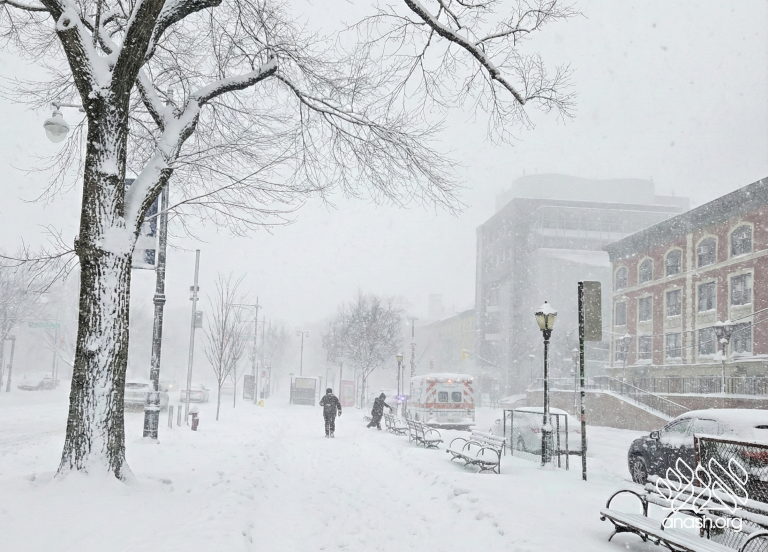
A powerful nor’easter is set to strike Brooklyn this weekend, bringing what forecasters say could be the most significant snowfall New York City has seen in nearly a decade. A Blizzard Warning is in effect for all five boroughs — including Crown Heights and East Flatbush — from Sunday afternoon through Monday evening.
The National Weather Service is projecting 12 to 20 inches of snowfall citywide, with isolated totals potentially reaching two feet. The heaviest snow is expected overnight Sunday into Monday morning, with rates of one to two inches per hour and wind gusts up to 60 mph producing near-whiteout conditions across Brooklyn. Temperatures are expected to plunge into the mid-20s following the storm, with wind chills in the teens, raising concern that any daytime melting will refreeze overnight, leaving dangerous icy conditions persisting into Tuesday.
The forecast represents roughly double the accumulation that fell across Crown Heights during last month’s Winter Storm Fern, which deposited approximately 8 to 11 inches in late January. That storm’s snow had only just fully disappeared this past week, following several days of rain and milder temperatures — giving residents little breathing room before the next system arrived.
“The snow from a month ago literally just melted — last drops still standing as we speak — and it’s about to snow again,” one Crown Heights-area resident wrote Friday. A second resident wrote: “I’ve lived in Brooklyn all my life. Crown Heights almost twenty years. We never had this issue to this extent back in the day.”
Others pointed to the city’s handling of the January cleanup. “The mayor… are pretty new to the city and the last big storm ppl cleaned the snow faster… couldn’t handle it,” wrote one resident. Another added: “We are all trying to navigate massive snow piles that have pushed from the street and are now frozen solid.” With the blizzard warning now in effect, few are optimistic. “And yet, this is not bad! It’s worse right now, been a week since a big snowfall, city’s not picking it up and it’s coming again, tomorrow!” wrote one neighbor. “Snow in Crown Heights… just when the old snow disappears, here comes more,” wrote another.
Governor Kathy Hochul declared a State of Emergency for New York City and surrounding counties on Friday, activating the National Guard. Citing forecasts of 18 to 24 inches for the city and Long Island, with wind gusts potentially exceeding 60 mph, the Governor urged all residents to remain home for the duration of the storm. “New Yorkers are no strangers to snow and cold weather, but these blizzard-like conditions approaching New York City, Long Island and the lower Mid-Hudson will bring heavy snow and strong winds,” she said. “I encourage everyone to take action, stay vigilant and always monitor your local forecast for real-time updates.”
Mayor Zohran Kwame Mamdani described the approaching storm as the city’s first blizzard since 2016, warning that conditions could prove even more dangerous than last month’s event. “We are now expecting between 13 and 17 inches of snow. But there is a slight chance we may see up to 20 inches, or even more,” he said. “New Yorkers can expect that the Monday morning commute will be extremely hazardous, with heavy snowfall and peak winds coinciding to create slippery conditions and greatly reduced visibility. I am asking all New Yorkers to stay inside and stay off the roads for your safety.”
NYC Emergency Management Commissioner Christina Farrell mirrored that notice, urging locals to check on neighbors as conditions deteriorate. “New Yorkers should prepare for what could be the most significant snowfall we’ve seen this year,” she said. “Heavy snow, strong winds, and coastal flooding have the potential to make travel dangerous from Sunday afternoon through Monday morning. We’re asking New Yorkers to do their part: stay informed, avoid unnecessary travel, and check on your neighbors.”
Alternate Side Parking has been suspended citywide for Monday.
The city’s Department of Sanitation has issued a full Snow Alert effective 6:00 a.m. Sunday, deploying over 700 salt spreaders, thousands of plow trucks, and more than 1,000 emergency snow shovelers across the city. Acting DSNY Commissioner Javier Lojan acknowledged the scale of the operation while asking for the public’s cooperation. “DSNY is preparing for a massive deployment, but our work is more difficult if you are on the roads,” he said. “Do your part to help our work by staying off the roads and staying safe.”


We appreciate your feedback. If you have any additional information to contribute to this article, it will be added below.